 |
Margate before Sea bathing: 1300 to 1736
Anthony Lee
Margate before Sea bathing
An on-line version of this book is available below, but a print version is also available.
|
Margate before Sea Bathing: The early history of a Seaside Town Anthony Lee Margate was to become one of the first English seaside resorts, but it had been little more than a fishing village before the pleasures of sea bathing became popular in the early eighteenth century. This book uses a wide range of original documents to describe the early history of Margate, to show what life was like in Margate at the time, and to show how the foundations were laid for the town’s future importance. . 388 pages, paperback. Available from Amazon.co.uk at £14.64: free postage |
Dates and Money
A Note on Dates:
From the 12th century until 1751, as well as the historical year starting on 1 January, there was a civil year, starting on 25 March (Lady day). This means that, in this period, any day between 1 January and 24 March inclusive would be in different historical and civil years. For example, 7 February 1694 in the historical calendar corresponds to 7 February 1693 in the civil calendar; such a date would sometime appear in records as 7 February 1693-4, to take account of the two calendars. After 1751 only the historical year was used. Here, all dates are written as historical years.
A Note on Money:
Values were expressed in units of pounds, shillings, and pence: £3 7s 6d is three pounds, seven shillings and six pence.
1 pound (£1) = 20 shillings (20s)
1 shilling (1s) = 12 pence (12d)
1 guinea = 21s
Farthing = ¼d
Some Useful Web Sites for Dates and Units:
Historical calendars, 500-2199: Excel calculator
Pounds, shillings and pence (LSD) calculator: Excel calculator
Units:
Regnal Years
Edward I |
20 Nov. 1272-7 July 1307 |
Edward II |
8 July 1307-20 Jan. 1327 |
Edward III |
25 Jan. 1327-21 June 1377 |
Richard II |
22 June 1377-29 Sept. 1399 |
Henry IV |
30 Sept. 1399-20 Mar. 1413 |
Henry V |
21 Mar. 1413-31 Aug. 1422 |
Henry VI |
1 Sept. 1422-4 Mar. 1461 |
|
(and 9 Oct. 1470-14 Apr. 1471) |
Edward IV |
4 Mar. 1461-9 Apr. 1483 |
Edward V |
9 Apr. 1483-25 June 1483 |
Richard III |
26 June 1483-22 Aug. 1485 |
Henry VII |
22 Aug. 1485-21 Apr. 1509 |
Henry VIII |
22 Apr. 1509-28 Jan. 1547 |
Edward VI |
28 Jan. 1547-6 July 1553 |
Mary |
6 July 1553-24 July 1554 |
Philip and Mary |
25 July 1554-17 Nov. 1558 |
Elizabeth I |
17 Nov. 1558-24 Mar. 1603 |
James I |
24 Mar. 1603-27 Mar. 1625 |
Charles I |
27 Mar. 1625-30 Jan. 1649 |
Interregnum |
30 Jan. 1649-29 May 1660 |
Charles II |
29 May 1660-6 Feb. 1685 |
|
(but reckoned from 30 Jan. 1649) |
James II |
6 Feb. 1685-11 Dec. 1688 |
Interregnum |
12 Dec. 1688-12 Feb. 1689 |
William and Mary |
13 Feb. 1689-27 Dec. 1694 |
William III |
28 Dec. 1694-8 Mar. 1702 |
Anne |
8 Mar. 1702-1 Aug. 1714 |
George I |
1 Aug. 1714-11 June 1727 |
George II |
11 June 1727-25 Oct. 1760 |
George III |
25 Oct. 1760-29 Jan. 1820 |
From: David Hey, (Ed.), The Oxford Companion to Family and Local History, Oxford University Press, 2008.
Introduction
Even then Margate received a bad press. John Leland, visiting the town during his famous tour of England in 1535-1543, wrote that ‘Margate lyith in St John’s paroche, yn Thant, a V myles upward fro Reculver, and there is a village and a peere for shyppes, but now sore decayed’.1 John Eveleyn who visited Margate in 1672 described the town as consisting of ‘brewers of a certain heady ale [Northdown Ale]’ with a good trade in malt, but ‘for the rest is raggedly built; and an ill haven, with a small fort of little concernement’.2 A member of William III’s household reported in 1691 that, returning from the continent, the King landed at a ‘wretched village called Marguet’.3 Things were no better in the 1720s when Daniel Defoe visited the town: ‘The town of Margate is eminent for nothing that I know of, but for King William's frequently landing here in his returns from Holland, and for shipping a vast quantity of corn for London Market’.4 Even John Lewis, vicar of the local parish, described Margate in 1723 as ‘a small fishing town, irregularly built, and the houses very low’.5
Until the early part of the eighteenth century Margate was, then, little more than a village, depending on farming and shipping for its survival. It was known by a variety of names including Marguet, Mergate and Meregate and lay on the northern coast of the Isle of Thanet, in the parish of St John’s, one of the seven parishes in the island, the others being St Peter’s, St Lawrence, Minster, Birchington, St. Nicholas and Monkton. Although in fact the Isle of Thanet was no longer an island it had once been separated from the rest of Kent by the rivers Stour and Wantsom and still kept the name. The parish of St John’s was about three and a half miles across in each direction and Margate occupied just a small part of the parish.6
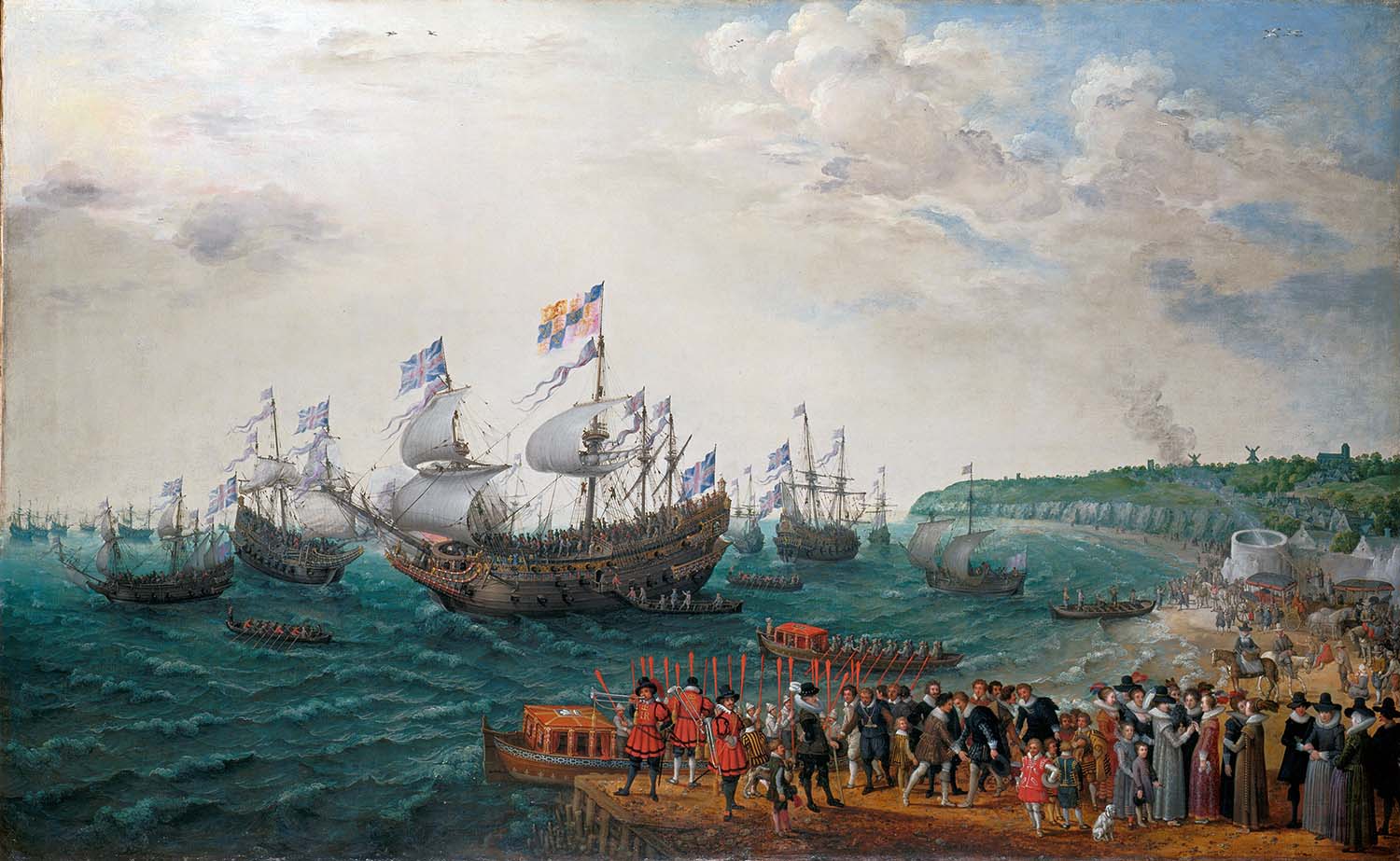 |
Figure 1. Adam Willaerts, ‘The Embarkation at Margate of the Elector Palatine and Princess Elizabeth’ in 1613, painted in 1623. |
The first picture we have of Margate is in an oil painting, The Embarkation at Margate of Elector Palatine and Princess Elizabeth, by the Dutch painter Adam Willaerts, dating from 1623, one of a series illustrating the marriage of the Elector Palantine to Princess Elizabeth, the daughter of James I (Figure 1). After the marriage ceremony, the couple and their retinue travelled to the coast at Margate where they boarded the English flagship, Prince Royal, and eventually set sail for the continent on April 25 1613. The painting shows the royal couple about to board the Prince Royal with Margate represented by a small cluster of houses in a gap in the cliffs. Houses climb a hill to the left, with a church and two windmills on the horizon; on the sea shore itself is a large cylindrical structure issuing smoke. Although Willaerts lived most of his life in Utrecht he was born in London,7 and it is possible that he actually saw Margate on his travels from London to Holland. If so, his picture of Margate could be more than just a formulaic representation of a typical English scene. The large cylindrical structure on the shore is puzzling and, if not a fort of some kind, it could represent a lime kiln or a kiln for burning seaweed to make kelp, a process that was common in Margate at the time.
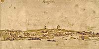 |
Figure 2. A watercolour of ‘Marcoaet’, in the collection of the British Museum, by the Dutch artist Michiel van Overbeck, who was in England between 1663 and 1666. A higher resolution version can be seen at the British Museum web site.
|
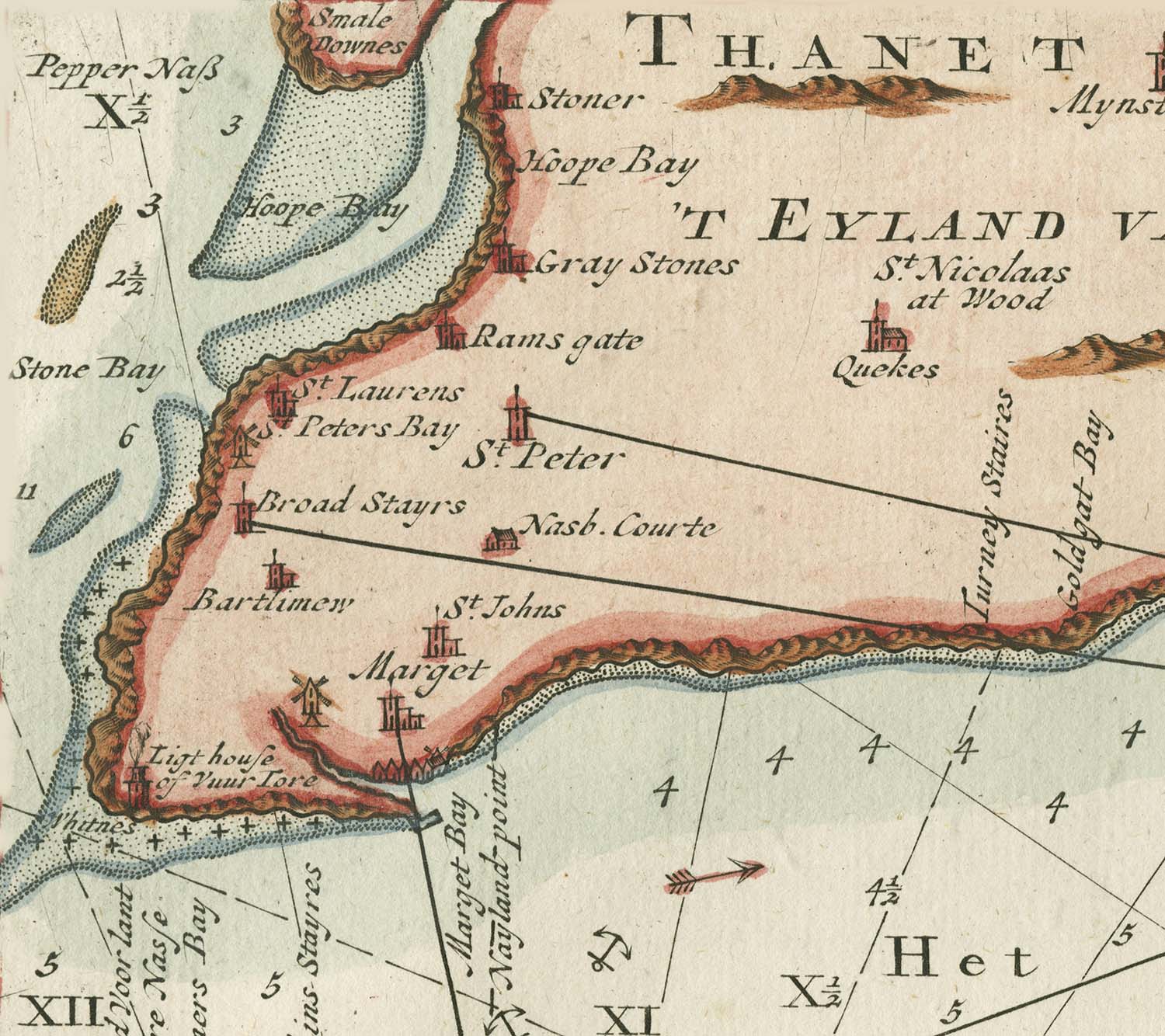 |
Figure 3. A sea chart of the Thanet coast by Gerard van Keulen based on an original by his father Johannes van Keulen, showing the coast in the 1680s. |
Luckily there is no ambiguity about the second early picture of Margate, a watercolour by another Dutch artist, Michiel van Overbeck, who was in England between 1663 and 1666 (Figure 2). The drawing, labelled ‘Marcoaet’, shows high cliffs to the east and low ones to the west, on either side of a large creek; a boat is shown entering the creek. Buildings line the creek and, as in Willaerts’ picture, climb up the slopes of the hill leading to the Church; there is a windmill on the horizon. The ramshackle state of the harbour is all too apparent. An early Dutch sea chart of the Thanet coast by Gerard van Keulen, based on an original by his father Johannes van Keulen dating from about 1680, again shows the creek at Margate extending a considerable way inland (Figure 3).
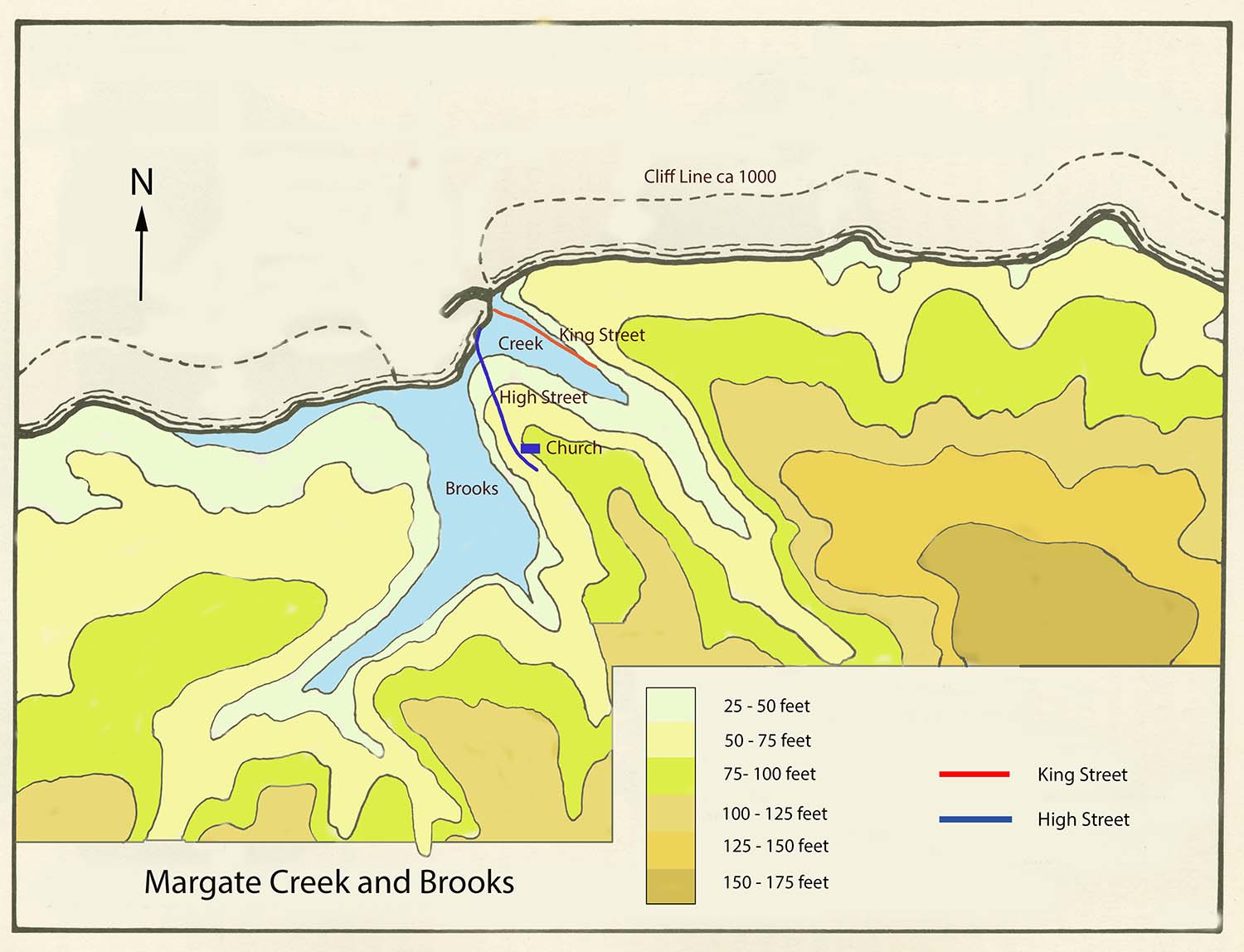 |
Figure 4. Contour map for Margate and the surrounding country, based on a map in David Scurrell, ‘The Book of Margate’. The Brooks, to the west, and the Creek, to the east, are shown in blue. The approximate positions of the High Street, King Street and the church are shown. |
Deposits of sand and sea pebbles have often been uncovered during building work in Margate, showing that the creek used to extend from the sea along the line of the present King Street and Dane Road (Figure 4). The original line of the creek can easily be traced in modern maps of the town. As described by Arthur Rowe ‘we have to picture to ourselves a Creek which was always tidal to some extent, and when northerly gales and high spring tides prevailed we can well imagine that the sea rushed up what is now King Street almost as far as Addiscombe Road’.8 Further along Dane Valley, salt water driven inland would have met fresh water issuing from the many springs lining the sides of the valley; at one time the Creek would have drained the whole of the Dane Valley. Again quoting Arthur Rowe, the presence of a sheltered creek and ample spring water made the area suitable for settlement: ‘early sea-faring man asked but three things — spring-water to drink, a reasonably safe offing for his fishing, and a secure haven for his little dug-out boats, which he could draw up on the high ground when the sea bore too heavily on him. ’8
The creek, at its seaward end, was some 150 yards wide, stretching between the bottom end of the High Street and the northern side of King Street at its junction with the Parade at the bottom of Fort Hill. The southern boundary of the creek followed the line of Market Street, Market Place and Lombard Street, and through what was Garden Row and is now the supermarket at the bottom of Hawley Street; the northern boundary of the creek followed the line of King Street and Dane Road.8,9 Buildings on the Parade and those in Broad Street, Duke Street, Market Place, the bottom of Hawley Street and the lower part of King Street all had to have their foundations strengthened by piles because of the old creek.8 Excavations in King Street have uncovered timber piles that could have lined the sides of the creek.9
With time the main channel of the creek became narrower and, together with several of its branches, came to serve as an open drain for the town. As late as 1799 Carey described the area thus: ‘What the old Parade might have been is no easy matter to tell, but in its present state, and in this improving age, it has little to boast of in respect to elegance, or even cleanliness, and in rainy weather it is a mere swamp. The greater part of it lies between a noisy stable-yard, well furnished with manure, and the common sewer of the contiguous Market Place [then an open channel] as well as all the lower part of the town, which frequently yields up the most ungrateful exhalations and unsavoury smells to those who choose to regale themselves in this delicious neighbourhood’.10
Growth of Margate to the west was limited by another stretch of water, a mere or lake, commonly called the Brooks (Figure 4). This originally formed a large sheet of water measuring some 300 yards at its outlet, extending inland as far as the site of the Tivoli Gardens and cut off from the sea by a sand-bar.8 The Brooks gradually silted up to form a marshy area intersected by ditches, making it difficult to enter the town from the west. Because of the Brooks there was no coach road along the coast; the road from Sarre to St Nicholas at Wade, Birchington and Westgate was only a bridle-track ending at the cliff edge near Westbrook Mill, where Royal Crescent now stands. The lack of a road from Westbrook Mill into Margate meant that the few inhabitants of Westbrook would often be cut off from Margate, except at low water; access to the town at high tide could only be obtained by passing through the fields to Salmestone and Frog Hill.8 The land to the west of Margate was only developed after a massive road embankment was carried along the shore line early in the nineteenth century, although even then Lower Marine Terrace had to be built on exceptionally long piles and the London Chatham and Dover Railway embankment across the Brooks had to be built on thousands of bundles of brushwood sunk into the marsh land.8
The best description of Margate in its early days is that provided by John Lewis in his History and antiquities ecclesiastical and civil of the Isle of Tenet in Kent, published in 1723:5
Mergate seems to have had its name from their being in it a gate or way into the Sea which lies just by a little Mere, called by the inhabitants now the Brooks. By this gate is situated the vill [vill is an old term for a hamlet or village] called Meregate, partly on the side of a hill, and partly in a little valley one end of which goes into the sea. It is a small Fishing Town, irregularly built, and the houses very low, and has formerly been of good repute for the fishing and coasting Trade.
On that part of the town which lies next the Sea, is a Peer of timber, built East and West, in the form of a half moon to defend the bay from the main sea, and make a small harbour . . . By the present appearance of the Chalky rocks on each side of this Peer at low water, it should seem as if anciently Nature itself had formed a Creek or harbour there, the mouth of which was just broad enough to let small vessels go in it. But, as the land on each side of this creek was, in the process of time, washed away by the sea, the inhabitants were obliged to build this Peer, to keep their town from being overflown by the ocean; and to defend that part of it which lies next the water by Jettes, or Piles of timber. This Peer was at first, but small, and went but a little way out into the sea; But the land still continuing to wash away, so that the sea lay more heavily on the back of it than usual, it has been, by degrees, enlarged.
On a little Hill, about half a Mile from the lower part of Mergate next the Sea, stands the Church, which is dedicated to St John Baptist.
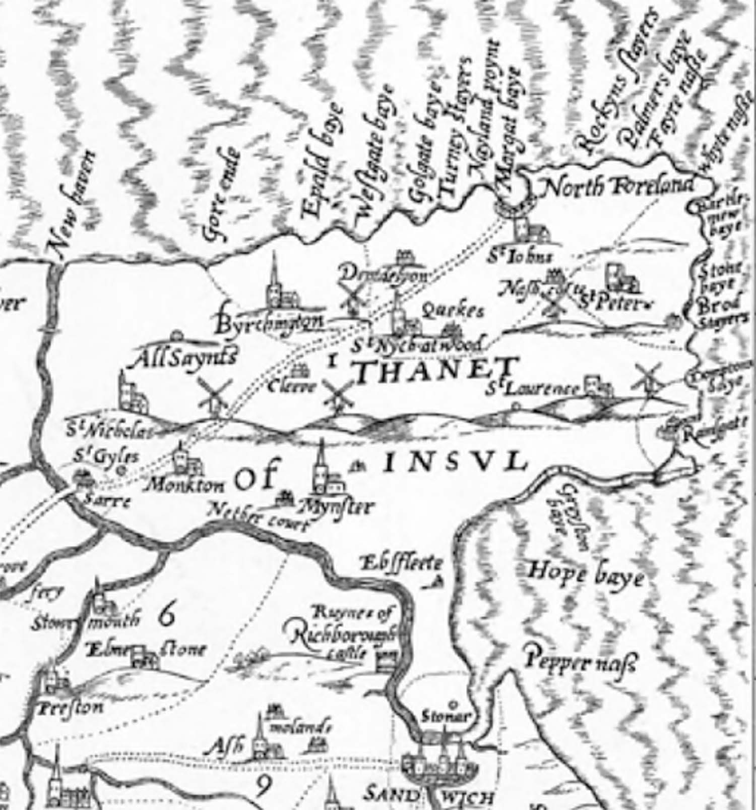 |
Figure 5. Detail from the half-inch scale map of Kent surveyed by Philip Symonson and published in 1596. |
The extent of the erosion around the creek referred to by Lewis is obvious in maps of the coast line. The most accurate of the early maps of Kent is a half-inch scale map surveyed and drawn by Philip Symonson and published in 1596.11 This shows the bay as a clear half-circle (Figure 5), very different from what is shown on modern maps where much of the surrounding cliffs have gone, particularly on the east side.
Lewis described the rest of the parish of St John’s as follows:5
Besides the vill of Mergate, there are other lesser vills or clusters of houses in this parish, viz. 1. West-brooke, so called for being situate on the west-side of the Mere just by Mergate, commonly called the Brooks. 2. Garlinge, which is a pretty large vill, consisting of about 20 or 30 houses, about midway betwixt Mergate and Birchington. 3. Shonken-dane. 4. Lyden. 5. Flete. 6. Little Nash, partly in this parish and partly in St Peter’s. 7. East-North-down, which is likewise part of it in St Peter’s. 8. West-North-down. 9. Lucas-dane, almost joining to Mergate East, in the same valley.
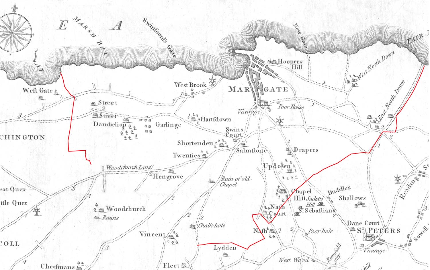 |
Figure 6. The parish of St John the Baptist. The parish boundary, shown in red, taken from the parish map of William Edmunds, 1841, has been superimposed on Hall’s Map of the Isle of Thanet of 1777. Edmund’s parish map lacks the south west corner of the parish and so the parish boundary is incomplete in this region.
|
 |
Figure 7. Detail from Crutchley’s Environments of Margate, 1823, showing the location of Lucas Dane.
|
The parish boundary and its relation to Margate and to the other small settlements is shown in Figure 6.
Margate probably developed from two small hamlets, one a group of fishermen’s cottages nestling around the outlet of the creek, and the other a group of houses clustered around the parish church that had been built in about 1050 on elevated ground about half a mile from the creek. A third hamlet, straggling along the valley marked by the present King Street and Dane Road, was known as Wilds Dane, Lucas Dane, Lucks Dane, Luke Dane, or Luke’s Dane, from the Anglo-Saxon ‘denu’, a valley.12,13 Lewis, in the quotation just given, referred to it as ‘almost joining to Mergate East, in the same valley.’ The name persisted locally in the parish rate books until about 1800, with the valley farm being known as Luke Dane Farm, Lukes Dane Farm, or Lucas Dane Farm.12 Lucas Dane is rarely named on maps of Margate, but does appear on Crutchley’s map of 1823 (Figure 7). The origin of the name is uncertain, but a will from St John’s, that of John Safoull in 1474, includes a bequest ‘to Simon Grannte a certain messuage called Lukke and six acres of land, to his heirs for ever’, and another local will, that of Simon Grannt in 1486, includes a bequest to his wife Isabella of ‘my tenement called Lukks, and thirty acres of land until my son comes to the age of 20 years then to John’.14 Lucas Dane could have taken its name from the house called Lukke or Lukks. The will of John Lucas, a ‘shipman’, in 1486 leaves land to his wife Alice at ‘the Lutt park’, which, given the difficulty in distinguishing between the written ‘t’ and ‘c’ could also be read as ‘Luce park’; Lucas Dane could therefore also take its name from the family of Lucas.14
Another ‘Dane’ also appears in early wills, Palmer Dane. The will of Thomas Baseley of St John’s in 1479 leaves to his sister Agnes ‘three acres of land situated in Palmers Dane, and to her heirs for ever’, that of Simon att Berough in 1491 decrees that ‘one acre and a half in the Cumbe [a valley] and three rods at Palmerden shall be sold to pay my debts’, and that of Roger Johnson in 1498 decrees that ‘one acres and half of land at Palmersden to be sold, and the money to my wife Joan to pay debts’.14 The location of Palmer Dane is not known.
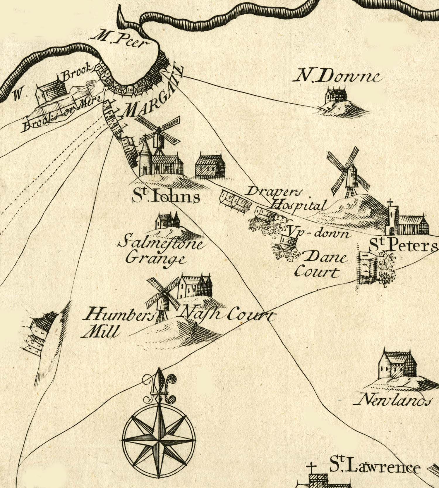 |
Figure 8. A section from Harris’s map of the Isle of Thanet of 1717, showing the parish of St John’s. From John Harris, ‘History of Kent’, D. Midwinter, London, 1719.
|
The two main settlements, around the creek and around the church, are still clear in Harris’s map of the Isle of Thanet of 1717 (Figure 8). Buildings can be seen concentrated around the creek and along the road leading to St John’s church, and it seems likely that the name Margate referred initially to just this built up area. The earliest surviving Parish Rate Book dating from 1666 shows that the Parish Overseers for the Poor divided the parish into three parts: the first corresponded to the outlying regions of the parish, Nash, Fleet and Lidden, Westbrook, Garlinge, Dandelyon, and Northdown; the second, Church hill, corresponded to the area around the church, including much farm land; and the third, Margate, contained the largest number of rateable properties in the parish, and was concentrated close to the harbour.15 Precisely which parts of the parish were covered by the name Margate is not totally clear and even at the time could lead to confusion. For example, in the thirteenth century the original Confederation of the Cinque Ports was extended with the addition of new members referred to as ‘limbs’, one of which was Margate, which became a limb of Dover.16,17 This meant that Margate shared the privileges of the other members of the Cinque Ports and was answerable to the Justices of the Peace at Dover and not to the Justices of the Peace for Kent (Chapter 5). However, from time to time the Justices of the Peace for Kent tried to claim that the part of the parish of St John’s that was not Margate came under their jurisdiction.18 This situation was clearly untenable and Henry VIII solved the problem by also making St John’s a limb of Dover, even though this meant that Margate was effectively included twice in the charter, once under its own name and once as part of St John’s parish.17,18 Dover simply considered Margate and St John’s as one for purposes of taxation: in 1521 when the Cinque Ports received a demand for a levy from the King ‘Margate and St John’ was ordered to pay 26s 8d,19 and a list of debts due to Dover in 1530 included ‘the contribution and forfeit of Margate and St John’s, in Thanet, 53s 4d, unpaid cess money, fines and poundgelt’.20 The issue of the exact boundary between Margate and the rest of the parish was only to become important much later with the introduction of property rates, different for town and country properties.
The populations of Margate and of the parish of St John’s are uncertain before the nineteenth century, but it is possible to make some rough estimates. In the reign of Edward I (1272-1307) a tax, the Romescot, was collected on every hearth, and sent to Rome. The number of inhabitants of St John’s paying the tax was 208, compared to 141 at St Lawrence and 163 at St Peter.21 Assuming an average of five per household, this would suggest a total population for the parish of about 1000. In 1377 the first poll tax was introduced, at a flat rate of one groat, ie four pence, charged on everyone over the age of 16, both male and female, with exceptions that included the clergy and those who could demonstrate that they were genuinely paupers. The number taxed in the parish of St John’s was 264, compared to 54 in Birchington.22 Although widespread evasion of the tax makes it difficult to use this figure to calculate an accuarte population, it suggests a minimum population for the parish of about 600. Margaret Bolton used parish registers and probate records to estimate a population for the parish of about 810 in 1558, at the start of the reign of Elizabeth I, and 1020 in 1603, at the end of her reign.23 A survey taken in 1566 reported that Margate had 108 houses and 8 ‘persons lacking proper habitation’.24 At the visitation of Archbishop Parker in 1569 the number of houses in the parish was reported to be 120, with 400 communicants.25 The muster role of 1599 lists 158 men for the Parish of St John’s, a number that probably included all the able-bodied men in the parish;23 an average of 5 per household would then give a population for the parish of around 800. When the hearth or chimney tax was collected in 1673 there were 552 hearths in the parish, in 174 houses; 100 houses occupied by the poor were excused.21 In the Isle of Thanet as a whole there were 1142 houses, of which 364 were excused payment of the hearth tax.21 A total of 274 houses in St John’s suggests a total population of about 1,400 for the parish. A census of church goers in 1676 suggests an adult population for the parish of about 750 which, assuming 0.66 children per adult, gives a total population of about 1,300.26 A similar number can be estimated from the 55 burials in 1680 which, assuming a scaling factor of 31 between population and burials, gives a population of about 1,700.27,28 Lewis, in his History of the Isle of Thanet, estimated that there were about six hundred families in the parish in 1723, giving a population of about 2,400.5 In 1781 there were 444 inhabited houses in the parish chargeable to window duties.29
It has been suggested that for a settlement to be counted as a town it had to have an independent local government, a diverse economic base, and a market; it also had to be a social and religious centre.30 By these criteria Canterbury, Dover, Maidstone and Rochester were indisputably towns, but Margate was not. Indeed a list of 26 towns in Kent produced by John Norden in 1625 did not include Margate, and Margate was not one of the twelve towns in Kent listed by the early Tudor traveller John Leland.30 A reading of the local newspaper, the Kentish Post , also suggests that Margate had few of the amenities expected of a fully-fledged town. For example the newspaper, in 1726, included advertisements for the sale of goods, properties and services in many local towns including Canterbury, Deal, Dover, Ramsgate and Sandwich, but none for Margate; Margate, it seems, had little to offer the surrounding towns. Nevertheless, even today the distinction between a small town and a large village is often unclear and Mary Dobson has described many of the towns in Kent as being ‘little more than overgrown villages, focused on and extending into the surrounding fields. Pigs and people roamed around the towns just as they did in the countryside. Kent in the seventeenth century was essentially a landscape of farming regions studded only with an array of small towns and cities serving, for the most part, the needs of a rural hinterland’.31 Even in 1800 Edward Hasted in his History and Topographical Survey of the County of Kent was uncertain of the status of Margate, referring to it as ‘the village or town, now called Margate’. What is certain is that Margate was the largest of the settlements in the Isle of Thanet, the population of Ramsgate in 1671, for example, being estimated to be 701, compared to the estimate of 1,173 for Margate.32 This, combined with its extensive trade with London by sea, gave Margate at least some of the characteristics of a town, and, for simplicity, in what follows Margate will be referred to as a town.
Here the history of Margate is taken up to 1736, a date less arbitrary than it may at first seem. The fortunes of Margate were to be transformed by the fashion for sea bathing. Bathing and swimming have, of course, very long histories. The first book on swimming written in English, Everard Digby's A Short Introduction for to Learne to Swimme, was published as early as 1595, and William Shakespeare, in King Henry VIII, had Cardinal Wolsey say of his fall from power:
I have ventur'd
Like little wanton boys that swim on bladders,
These many summers in a sea of glory;
But far beyond my depth.
Even some Margate sailors knew how to swim, according to a report in the Newcastle Courant in 1739:33
On Tuesday morning last two young fellows, sailors belonging to Margate, went in a fishing boat to catch whitings and were drowned. They were taken up by the next day, and it was observed one of them had ript his boots, untied his handkerchief, and loosened his shirt buttons, to facilitate his swimming. They have left two young widows, and two children each.
The commercial potential of sea bathing only became apparent in the eighteenth century, a potential first realised in Margate by Thomas Barber, a local carpenter, who placed the following advertisement in the Kentish Post in 1736:34
Whereas Bathing in Sea-Water has for several Years, and by great Numbers of People, been found to be of great Service in many Cronical Cases, but for want of a convenient and private Bathing Place, many of both Sexes have not cared to expose themselves to the Open Air: This is to inform all Persons that Thomas Barber, Carpenter, at Margate, in the Isle of Thanett, hath lately made a very convenient Bath, into which the Sea Water runs every tide through a Channel about 15 Foot long; You descend into the Bath from a private Room adjoining to it.
N.B. There are in the same House convenient Lodgings to be Lett.
The advertisement makes it clear that bathing in sea water at Margate for medical reasons was already fairly common by 1736. This though was the first time that facilities had been provided specifically for visitors to Margate who wished to bathe in the sea, or, at least, in sea water. From these humble beginnings the ‘House’ referred to in the advertisement, the Black Horse Inn, developed into a major hotel and Margate developed into a town with assembly rooms, subscription balls, theatres, promenades, circulating libraries, and orchestras. Margate was no longer to be ‘a small fishing town, irregularly built’.